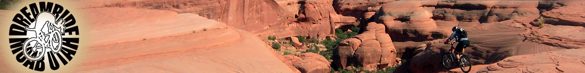


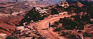
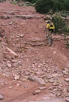
MOAB MOUNTAIN BIKE TRAILS
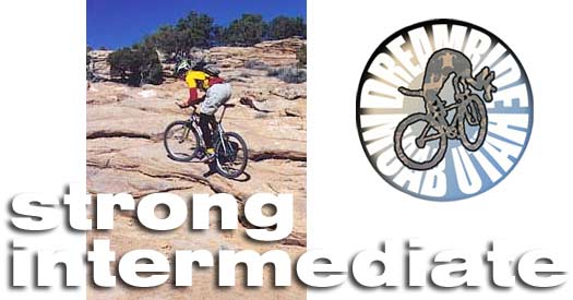
strong intermediate skill level
A STRONG INTERMEDIATE rider is fit and experienced with a few years of riding to build a level of confidence, and solid aerobic fitness gained from other sports, such as cross country skiing, running or tennis. A strong intermediate can jump a curb with both wheels, comfortably drop a front wheel over a two foot ledge and is capable of completing even the most difficult of trails in the Moab area. Intermediate riders have enough experience and common sense to recognize trail sections that are beyond their abilities. Knowing the percentages and recognizing the consequences of simple mistakes are skills acquired by moderately experienced cyclists. A strong intermediate can ride a steady non-technical 2000 foot climb in 5 miles without having to put a foot down to rest. If you are from Northern California and consider yourself to be an advanced rider in that environment, you are most likely an intermediate or strong intermediate in Moab. If you are a road biker from Northern Calfornia that also mountain bikes in the Sierras, you are probably a strong intermediate to advanced rider when it comes to riding Moab terrain.
Dreamride's best routes are top secret! If you are looking for extreme solitude, hardcore riding, pristine environment and rare wildlife viewing, that is what Dreamride specializes in. Listings here are traditional mountain biking areas listed in guidebooks and on maps that can be bought. Our favorite routes are not listed anywhere.
This listing is provided by Dreamride LLC of Moab, highlighting a small sampling of trails offered as part of the company's Moab Vacation Packages. For your information, Dreamride does not list the majority of its custom tour routes, keeping them secret for our clients only. If you are looking for more information on mountain bike trails in the Moab area click on OUTDOOR AMERICA MOAB GUIDEBOOK. Be sure to visit the SAFETY GUIDE before coming to Moab. It could save your life and contains valuable environmental information that is required knowledge for all visitors to canyon country. For information on tour packages and other services offered by Dreamride in Uath, Hawaii, and Colorado, click on VACATION CATALOG or CONTACT DREAMRIDE.
Group maximum size: 6
From the trailhead on highway 191 up Little Canyon
past the Gooneybird and up the hill toward Gemini Bridges. We take an obscure spur to to travel out to the rim, completing a huge loop that reconnects with the Gemini Bridges Trail. The ride includes one of the most awesome technical downhills in canyon country. We can choose to visit Gemini Bridges, Bull Canyon, or Two Tortoise Rock, making for mileage and technical fun.
This ride is amazingly technical and wonderously beautiful, for serious mountainbikers who are
serious photographers. We travel
out behind the incredible "beehives" along a very rugged 4WD road
(you'll wonder who in hell would want to take a motorized vehicle for such
abuse) that makes up the best half of the course for the 24 Hours of Moab race. The challenge is sand, ledges, bumps, short, steep rolling hills,
and sand-slogging climbs. We will drop down to Prostitute Butte for a snack
and to enjoy the shade, Picture Frame Arch, and some bumpy slickrock practice,
then head back on the Back of Behind Trail to the parked vehicle at the
trailhead. This is great morning ride in Summer. The 3/4 day option includes a ride to over Upper Hunter Canyon.
A word of caution if you ride Flat Pass without a guide the first time. There is a spur that grabs newcomers. If you find yourself out on this spur in a thunderstorm, it could be fatal. Use a good trailguide.
The tour begins with a drive through Castle Valley past La Sal Mountain
Loop Road and onto Castleton Gateway Road where tour members mount
bikes for the ride down Fisher Creek to Polar Mesa, past Cowhead Hill to
the Taylor Ranch. After a stop for a light lunch we head onward to Onion
Creek and down through the Narries splashing again and again through Onion
Creek to the Colorado.
Group maximum size: 6
Group maximum size: 4 of strong intermediate skills, or 8 mixed skills if booked as a private ride.
A technical climb and descent gives access to the Moab Entrada Tongue and a wash that takes us under some incredible rock formations. The trail surface varies
from sand to slickrock and all around is scattered Indian-worked chert,
agate, dinosaur bone and tracks and gizzard stones (gastroliths). Once we climbed up the slickrock tongue we follow dinosaur
tracks for a spectacular view.
Group maximum size: 4 (no mixed skills); 8 if booked as a private ride.
We begin with a visit to Mill Canyon dinosaur fossil site, then head straight
ahead into Mill Canyon across Courthouse Pasture and out to Monitor Butte.
We encircle the Monitor clockwise, then tuck behind Merrimac Butte. We will
stop at the backside of Merrimac Butte for snacks and slickrock skills fun,
then head to Determination Towers to ride around the slickrock shelf. We
will head back to the Mill Canyon Trail then take a spur that carries us
out and around unnamed buttes above Courthouse Pasture. We will travel
west of Courthouse Rock, visiting the Blue Buffalo rock art site, the head back to the trailhead, stopping to check out
the old Thompson-Moab stage coach rest stop and a spot next to a spring
where Indians once camped.
Group maximum size: 6
This is the route followed by the April Moab Rocks mountainbike race. We
shuttle to the head of Amasa Back Trail and mount up for the warm-up ride
up Kane Creek Road to Hurrah Pass. At the pass we drop down to the Colorado
River and travel onward through Jackson Hole to the portage called Jacob's
Ladder. We push our bikes (or ride if you can) up to the Amasa Back Trail
which takes us back down on a series of challenging rock ledge sections
to Kane Creek Road to complete a giant loop.
Group maximum size: 4 strong intermediate riders (no mixed skills).
Options for additional mileage are available. You can ride up from town to the trailhead or shuttle from any number of technical Jeep trail spurs up Sand Flats Road. Please do not ask for this trail as a single day tour. It requires skills evaluation. The singletrack portion of the ride above Jackass Canyon is exposed and very dangerous.
Group maximum size: 4 (no mixed skills unless booked as a private ride).
Group maximum size: 8
From the trailhead on highway
191 we ride up into Little Canyon past the Gooneybird and rather than going
up the hill toward Gemini Bridges, we go south to connect with the trail
to Two Tortoise Rock, a very technical trail with challenges similar to
Gold Bar Rim and Behind the Rocks. We hook into Trigger Road then ride out
under Gemini Bridges on the Bull Canyon Trail or take the option to visit rarely seen Dry Fork. We will be stopping under
the Gemini Bridges to snack and take photos, then ride back and up the Dry
Fork of Bull Canyon. We will loop back via the Gemini Bridges Trail to form a twisted lollipop of a ride.
Group maximum size: 4 (no mixed skills). 8 in private group (mixed skills OK).
The singletrack trails in these young ranges, especially in the La Sal Mountains, are always
extremely difficult, but the network of narrow service roads are novice
options that offer cool forest cruising for families. We recommend Taylor Flat for families or novices.
Group maximum size: 4 to 8, depending on environmental sensitivity of trail.
Trails: Aspen Flat (out and back or loop), Moonlight Meadow, Warner Lake, Oowah Lake, La Sal Loop, Gold Basin, Miners Basin to Bachelor Basin, Burro Pass, La Sal Pass, Sheepherder's Heaven, Indian Creek, Shay Mountain, Elk Ridge, The Seven Sisters, and more.
"Mountain Bike America's Moab guide is setting a new standard for guidebooks. Lee Bridgers' first-hand accounts give the reader a sense that they have some behind-the-scenes information about Moab." ~ Brian Fiske, Senior Editor of Mountain Bike Magazine
Lee Bridgers' Moab guidebook is now available in bookstores around the world. Get a signed copy: CONTACT DREAMRIDE.
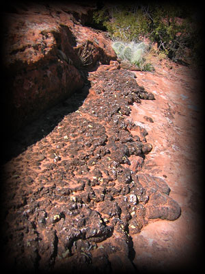
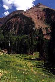
The Eagle's Perch
Another Moab epic for strong riders. This is a little known trail that has all the challenges associated with Moab terrain. See the picture above! Recommended
for riders who think they have ridden all the best trails in Moab, but haven't
heard of this one. Dart around Pinon Pine and Juniper
onto slickrock and sand and loose rock to spectacular views and wild rock
formations.
Surfaces: 4WD track, singletrack, slickrock, sand, rock ledges, loose rock,
de facto singletrack .
Distance: 23 to 27 miles
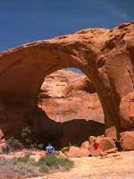
Attractions: Arches; views of Arches National Park from the rim above the
Moab fault; slickrock fun; twisty, rocky, desert track; distance riding.
Behind
the Rocks
Group maximum size: 8
Surfaces: Sand, ledges, up and down every kind of surface Moab has to offer,
except water crossings.
Distance: 12 miles
Attractions: Beauty and the beast! Remote.
Flat
Pass
Flat Pass is a challenging ride around a massive sandstone table between Moab
and the La Sals. We shuttle south, leave from the drainage into Ken's Lake and end with a wild downhill road ride into
Moab. It is an intermediate to advanced trek across ledgey slickrock, sand,
and loose round stones (babyheads delux).
Group maximum size: 6
Surfaces: 4WD track, loose rock, hard pack, rocky ledges, stream bed babyheads, sand,
slickrock.
Distance: 14 miles.
Attractions: Another classic Moab, Utah ride with stream crossings, red
rock ledges, and box canyons. A moderately strenuous intermediate to advanced ride with technical challenges.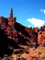
North
Beaver Mesa to Onion Creek
Group maximum size: 8
Surfaces: Loose rock, hard pack, rocky ledges, stream crossings on 4WD track.
Distance: 26 miles
Attractions: Constantly changing ecosystems. Outrageous scenery. Bring a
camera! Mostly downhill, but very challenging at the top. Ride gets easier
as we drop into Onion Creek's canyon. Kokopelli Options
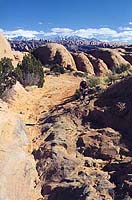
These rides are sections of the Kokopelli Trail 30 miles east of town--especially beautiful, sandy, and moderate to difficult in skill level. Yellow Jacket Canyon has some particularly interesting slickrock on its rim. Stay tuned for pictures!
Surfaces: 4WD track, loose rock, hard pack, sand, rocky ledges.
Attractions: Scenery. Solitude.
The Finger
This is one of our secret routes and cannot be found in any guidebook or on any map. It is a fantastic ride for those wishing
to be introduced to every kind of Moab subdesert terrain. Advanced riders enjoy this ride due to the options offered by slickrock expanses and various looping technical spurs. There are dino tracks and fossils
as well as its deposits of gem stone and, God save us, uranium. This custom route at the edge of the Moab Entrada Slickrock Tongue offers a few sections of slickrock and sand transititions that travel through tight washes and over rolling stone hills into an area of pristine wilderness inside the park--one of the rare treats only offered by Dreamride.
Surfaces: Dirt road, technical 4WD track, a bit of single track, sand, and
lots of beginner to intermediate level slickrock and ledges.
Distance: 10 miles +
Attractions: Vistas, vistas, vistas, dinosaur tracks; gemstone; awesome rock formations; historic
mine sites; Indian arrowhead factory; awesome stone bluffs.
Quasimoto
Incredible ride over the Camel's humps to Uranium Arch. This ride presents you with some challenging slickrock rollies and some extremely technical loose rock. Quasimoto lives on the edge of a huge cliff that is the western rim of the Moab Fault.
Surfaces: 4WD track, sand, slickrock, ledges, singletrack.
Distance: 17 miles
Attractions: Dinosaur bones galore at Mill Canyon; bizzare chert nodules
scattered everywhere; western history; geological spots of interest; slickrock
riding challenges; strange rock formations; wildlife; sand slogging (if
you like that sort of thing--we do); the only dirty petroglyphs around Moab. If your group wants to avoid most of
the sand we can take an out and back route, rather than the loop. THERE ARE LOTS OF OPTIONS OUT HERE.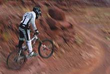
Moab
Rocks Epic
For riders who insist on going fast on changing trail surfaces.
Surfaces: Dirt road, gravel, technical 4WD track with loose rock, sand,
and slickrock ledges, rocky portage that can be ridden by strong experienced
riders--very challenging.
Distance: 25 miles
Attractions: Anasazi rock art; isolation; spectacular views of the Colorado
River gorge and the Jackson Hole area; strange rock formations; technical
riding challenges. This ride is a real workout.
Porcupine
Rim
Guts and glory. This legendary trail
can be dangerous without a guide the first time you ride it. It contains
a difficult, technical climb at the start, travels along a cliff overlooking
Castle Valley, then blasts downhill for a jarring ride that demands you
occasionally stop to check your bike. The ride ends with a very special
bit of singletrack that takes you down to the Colorado River.
Surfaces: Rocks, bedkrock ledges, ledges, sand, loose rock, packed sediments.
Distance: 18 miles.
Attractions: Bedrock jackhammer bumps. Spectacular vistas of Castle Valley, Priest and the Nuns and Castle Rock. Rare technical singletrack.
Poison
Spider Mesa
We get a lot of business from riders who we find lost on this trail. One of
the most popular trails around Moab, Poison Spider Mesa is recommended,
but should always be ridden with someone who knows the trail, at least for the first time. Make no mistake
the trail is difficult and contains some very challenging slickrock and
ledgey dropoffs, but it is appropriate for any intermediate rider or
strong mountainbiking family. Remember, if you are walking your mountainbike,
it's still mountainbiking. Can be done as an out and back or as the loop
described below, ending with the Portal Trail.
Surfaces: Technical 4WD track, sand, slickrock, ledges, banked sandy and/or
packed turns.
Distance: 16 miles
Attractions: Sickrock riding at its best! The view of Moab from the head
of the Portal Trail is worth the price of admission. Very many views of
the Portal from shadey spots along the rim.
Please do not ask to book this trail as a single day tour. This trail requires skills evaluation.
Dog Style
You may have heard of the Gemimi Bridges area. This ride travels out to below the bidges to the south in an area that few ride. The trail is varied and challenging.
Surfaces: 4WD track, sand, loose rock, rock ledges.
Distance: 20 miles +
Attractions: Wildlife, Gemini Bridges, spectacular canyon views, rock formations,
slickrock fins, arches, mining areas, challenging trail surfaces. Jughandle to Shafer Rim to Long Canyon Loop
An epic for those of you who crave LSD (long steady distance) and climbing on wide, relatively smooth trails. This is a great option for a strong road rider who wants to hammer on the dirt.
Surfaces: Bedrock, hardpack, sand, 4WD track, paved road, and just about everything else.
Distance: Up to 50 miles.
Attractions: Spectacular vistas, fantastic
buttes, weird colors and formations, and much more. LSD (long steady distance). Endorphine overload.
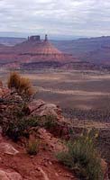
The La
Sal and Abajo Mountains
In summer and fall these two mountain ranges, among the three youngest on the planet, are filled with strong novice to highly advanced skill-level rides on singletrack that will simply blow your mind.
In summer the temperature is well below the hellish desert below (well, some of
us like hell, too). The singletrack in the Abajo Mountains is the very best anywhere in the United States. We highly recommend the Aspen Flat full day ride out to Shay Mountain Saddle, the best of the best singletrack, ending with an unimaginable view of the Maze and Needles Districts with the Henry Mountains in the distance. Lee Bridgers provided this location for the climax of the upcoming IMAX film EVEREST that will be released in February of 1998. See the film. See the view.
Surfaces: Singletrack, 4WD track, gravel, loose rock, hard pack, loam, rocky ledges,
stream bed, sand.
Distances: 10 to 55
Attractions: Abundant wildlife, beautiful views, cool forests, water,
fishing combos.Arches
by Moonlight
This nighttime road tour of Arches National Park is for the moonlighting
photographer on two wheels. Intermediate to advanced riders who crave something
very unique will be awed by the splendor and haunting beauty of the ride
out to the Devil's garden in spooky moonlight.
This is a perfect way to enjoy Arches in the heat of summer--an especially
quiet and mysterious way to see the park. THIS IS MAGIC.
Group maximum size: 8
Surface: Pavement.
Distance: 25 miles (optional dirt mileage available to groups).
Attractions: Moonlit views of spectacular vistas, impressive and strange
rock formations. Film and photography instruction by professional photographer.
"There are trail guides; and then there's the real deal." ~ Bike Magazine

Call 435-259-6419.
FAX number is 435-259-8196.
or write to:
Dreamride
P.O. Box 1137
Moab, UT 84532